 Alaska, the largest in area but one of the least populated U.S. states, lies astride the Arctic Circle, apart from the “Lower 48” conterminous states. It is bordered on the north by the Arctic Ocean, on the east by the Yukon Territory, on the southeast by British Columbia, on the south by the Gulf of Alaska and the Pacific Ocean, and on the west by the Bering Sea, the Bering Strait, and the Chukchi Sea. Little Diomede Island, in the Bering Strait, is only 4 km (2.5 mi) from Russia’s Big Diomede Island.
Initially inhabited by Eskimos, Aleuts, Athabascans, Tlingit, and Haida, Alaska was first visited by Europeans in the early 18th century. In 1867 the United States purchased Alaska from Russia for only $7.2 million. Alaska’s modern economic development was accelerated by World War II, when U.S. military bases were established here. Alaska became a state in 1959, and in 1968 great deposits of petroleum and natural gas were discovered in the Arctic coastal plain, or North Slope; commercial oil production from these fields began in 1977.
The name Alaska comes from an Aleut word thought to mean “mainland” or “land that is not an island”; the name originally was restricted to the Alaska Peninsula but by 1800 was used to denote all of present-day Alaska.
Land & Resources
 Alaska has vast areas of unspoiled natural beauty, including rugged, snowcapped mountains; spectacular glaciers; and vast expanses of rolling tundra. The state’s highest peak is Mount MCKINLEY, or Denali (6,194 m/20,320 ft), the loftiest point in North America. The state contains the northernmost land point of the United States–Point Barrow–as well as the country’s westernmost point–on western Attu Island (one of the ALEUTIAN ISLANDS). The western tip of the Seward Peninsula of Alaska is only about 80 km (50 mi) from the Russian mainland. Alaska has 10,684 km (6,639 mi) of general coastline–or 54,718 km (34,000 mi), if all the small islands and coastal indentations are included. About 80% of Alaska’s territory is owned by the federal government.
Physiographic Regions
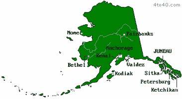
Alaska may be divided into four geographic regions–the Pacific mountain system of the south, the central region of uplands and lowlands, the BROOKS RANGE (the northernmost extension of the Rocky Mountains), and the Arctic coastal plain, or North Slope.
The Pacific mountain system is a complex region of high mountains, broad valleys, and many islands. The COAST RANGES dominate southeastern Alaska, a 644-km-long (400-mi) area known as the Alaska Panhandle. The ranges, many of which have large glaciers, rise to 5,489 m (18,008 ft) at Mount Saint Elias, in the Saint Elias Mountains, and to 4,996 m (16,391 ft) at Mount Blackburn, in the Wrangell Mountains. Just off the southeast coast is the ALEXANDER ARCHIPELAGO–about 1,100 islands that are the exposed tops of a submerged section of the Coast Ranges. These islands, separated by deep fjords, shelter the Inside Passage. The principal landform of south central Alaska is the Alaska Range, a great mountain arc that contains such lofty peaks as Mount McKinley and Mount Foraker (5,304 m/17,400 ft). In extreme south central Alaska is an extensive area of lowlands, along the lower Susitna River and on the western Kenai Peninsula. Southwestern Alaska is made up of the Alaska Peninsula, the Aleutian Islands, Kodiak Island, the Shumagin Islands, and several other islands. The Alaska Peninsula and the Aleutians are dominated by the volcanically active Aleutian Range.
Central Alaska, between the Alaska Range and the Brooks Range, contains modestly elevated mountains and large lowland regions, especially along the Yukon River and near the Bering Sea, in the west. Higher elevations include West Point (1,788 m/5,865 ft) in the east and Mount Bendeleben (1,137 m/3,730 ft) in the west on the Seward Peninsula.
In the north is the rugged Brooks Range, as well as the De Long, Baird, Schwatka, and Endicott mountains. Lofty points in the Brooks Range include Mount Isto (2,761 m/9,058 ft), Mount Chamberlin (2,749 m/9,019 ft), and Mount Michelson (2,699 m/8,855 ft), all situated in the northeast.
The Arctic coastal plain gradually slopes downward from the Brooks Range to the Arctic Ocean to the north. Permafrost lies under the surface of the plain, as do great deposits of petroleum and natural gas.
Rivers and Lakes
The chief river of Alaska is the YUKON, which flows westward across the central part of the state for 2,036 km (1,265 mi) before emptying into the Bering Sea through a large delta. The Yukon’s principal tributaries in Alaska are the Porcupine, Tanana, and Koyukuk rivers. Other major rivers in the state include the Kuskokwim, which flows westward to the Bering Sea; the Kobuk and Noatak, which empty into an arm of Kotzebue Sound; the Kokolik, Meade, and Colville, which flow into the Arctic Ocean; the Copper, which empties into the Gulf of Alaska; and the Susitna and Matanuska, which flow into Cook Inlet. Most of the rivers of the interior and the Arctic coastal plain carry much gravel and silt and display well-developed meander patterns.
Alaska has many lakes, the largest of which is Iliamna Lake (2,675 sq km/1,033 sq mi) in the south. Several big lakes, such as Becharof Lake, Naknek Lake, and Kukaklek Lake, are on the Alaska Peninsula. Lakes in Alaska have a tendency to fill in with vegetation. Often this leads to freezing of the subsurface material with uplift in the center of the former lake bed, which creates a hill known technically as a pingo.
Climate
Southeastern Alaska and the flanks of the Coast Ranges in south central Alaska, as well as the Aleutians, are characterized by a maritime climate. Some areas have a mean annual precipitation of more than 5,080 mm (200 in), with 1,651 mm (65 in) being normal for low-lying places. Temperatures are relatively mild in winter and usually are cool in summer. Juneau has average temperatures of -5 deg C (23 deg F) in January and 13 deg C (56 deg F) in July; the city receives about 1,016 mm (40 in) of moisture each year.
The lowlands along the lower Yukon and Kuskokwim rivers, the Cook Inlet area, the Copper River basin, and the southern Seward Peninsula have a transitional climate, with warm summers, cool winters, and precipitation ranging from 305 to 762 mm (12 to 30 in) a year. Summer temperatures are highest in the Copper River basin and decline to the west because of the moderating influence of the Bering Sea. Anchorage has a mean January temperature of -12 deg C (11 deg F) and an average July temperature of 14 deg C (58 deg F); its mean annual precipitation is 371 mm (15 in).
The interior of Alaska is shielded from marine influences by the Alaska and Brooks ranges. Thus it receives only 254-610 mm (10-24 in) of precipitation a year and has long winters, with typical temperatures of -40 deg C (-40 deg F) and occasional periods of several weeks duration when temperatures drop to -57 deg C (-70 deg F). Summers, however, usually are hot–temperatures reach 32 deg C (90 deg F), skies are clear, and sunlight lasts for twenty hours a day. Fairbanks has an average January temperature of -25 deg C (-13 deg F) and a mean July temperature of 16 deg C (61 deg F); it receives about 287 mm (11 in) of precipitation yearly. Northern and northwestern Alaska have arctic climates. This is the region of long, dark winters and short, cool summers, with 24 hours of darkness during part of the winter and 24 hours of daylight during part of the summer. Annual precipitation is low, normally between 203 and 533 mm (8 and 21 in). Winter temperatures are not as low as in the interior, but wind speeds are frequently high, causing extreme chill factors. The Beaufort Sea tends to moderate summer temperatures.
Vegetation and Animal Life
About half of Alaska is covered with tundra vegetation, which mainly consists of small plants (such as lichens, mosses, flowering plants, and grasses) and some high brush. Tundra is found on higher mountain slopes and covers most of western Alaska and all of Arctic Alaska. Almost one-third of the state is covered by forest. Southeastern and south central Alaska have large forests composed mainly of hemlock and Sitka spruce, and the interior has extensive forests of black and white spruce, birch, aspen, and larch. About one-sixth of the forest land is within the state’s two national forests, Chugach National Forest, in south central Alaska, and Tongass National Forest, in the southeast. Common flowering plants in the state include roses, lilacs, lilies, peonies, and delphiniums.
Alaskan wildlife includes numerous big animals. The southern part of the state has many bears (notably the Alaskan brown bear, the world’s largest carnivorous land mammal) and deer; large herds of fur seals are found on the PRIBILOF ISLANDS. Alaska has herds of moose, caribou, and reindeer, some domesticated musk-oxen, and mountain goats and sheep. Arctic Alaska has polar bears, caribou, and arctic foxes. The state’s numerous streams are well stocked with trout, salmon, grayling, and other fish, and coastal marine waters contain abundant salmon, halibut, cod, herring, pollack, shrimp, clams, and crabs as well as whales.
Historic Sites
Places of historic interest in Alaska include Klondike Gold Rush National Historical Park, including buildings in Skagway associated with the Klondike gold rush of 1897-98; Sitka National Historical Park, encompassing the site of the 1804 battle in which Tlingit Indians were defeated by Russian colonizers; and several communities in the Aleutian Islands and southern part of the state having Russian Orthodox churches dating from the early 19th century.
History
The first settlers of present-day Alaska migrated in successive waves from Asia across the BERING LAND BRIDGE; estimates of the date of the earliest such migration range from about 30,000 to 10,000 years ago. When the region was first visited by Europeans, in the early 18th century, it was inhabited by Eskimo in the north, west, and Prince William Sound area; Aleuts in the southeast; Athabascans in the interior and Cook Inlet area; and Tlingit and Tlairda in the southeast.
In 1728 the Danish navigator Vitus BERING, sailing for the Russian government, visited and named St. Lawrence Island, a part of modern Alaska situated in the Bering Sea. In 1741, Bering undertook a second voyage to Alaska, during which Mount Saint Elias was sighted and a party, under Aleksei Chirikov, landed at Kayak Island. Bering and many of his companions died during the trip, but some survivors returned to Russia with sea-otter furs from Alaska. Soon Russian adventurers were trapping in the Aleutian Islands, and in 1784, Grigory SHELEKHOV founded the first permanent white settlement in Alaska, on Kodiak Island, near modern Kodiak. During the late 18th century Capt. James COOK, the English explorer, as well as Spanish, French, and other English navigators, sailed along the coast of Alaska.
The early Russian trappers were disorganized and rapacious, depleting the stock of fur-bearing animals in many areas and killing or enslaving large numbers of Aleuts. In an attempt to bring order to Russian America, Tsar Paul I in 1799 chartered the RUSSIAN-AMERICAN COMPANY, granting it monopoly trading rights. Under Aleksandr BARANOV, who headed the company during 1800-17, the fur harvest was increased substantially, and several settlements were established. New Archangel (later renamed Sitka), founded in 1799, was destroyed by Tlingit Indians in 1802 but was rebuilt in 1804 as the capital of Russian America. At the same time, many Aleuts were then converted to Russian Orthodoxy, notably by Father Innokenti Veniaminoff.
During the first half of the 19th century, the Hudson’s Bay Company and American traders were very active in Alaska. The rights of these traders and most of the current boundaries of Alaska were established by treaties between Russia and Great Britain and the United States (1824-25).
From 1820 onward, the Russian-American Company, managed in large part by famous Russian admirals and scientists, did much to explore Alaska and assess its resources. The Russians built iron foundries and schools; developed coal mining, trading routes, farming, and sheep raising; followed wildlife conservation methods to preserve the fur-seal population; and carried out smallpox inoculations. As a result of the Crimean War and contacts with American businessmen in San Francisco, the Russian government wished to sell Alaska to the United States. The Russians feared losing Alaska to the British in the event of another war and were thus well disposed to the United States.
After the Civil War, U.S. secretary of state William H. SEWARD, an expansionist who saw the region as having strategic importance, negotiated (1867) the purchase of Alaska. A treaty of cession was signed by Russia and the United States on Mar. 30, 1867, and, after the treaty was ratified by the U.S. Senate, Alaska was formally transferred to the United States on Oct. 18, 1867. The United States paid $7.2 million for Russia’s rights in Alaska after a long and bitter debate in Congress. Americans occupied Alaska before the money was paid and moved quickly to take control of the assets of the Russian-American Company, to trade along the Yukon, and to exploit the profitable Pribilof fur-seal trade.
During the early years of U.S. control Alaska was called “Seward’s Folly” because it was believed to be useless. Although some economic development was undertaken, the region was generally neglected. It was administered successively by the U.S. War Department, Treasury Department, and Navy before civil government was established by the Organic Act of 1884. The government had little control of Alaska, however, until further laws were enacted in the early 1900s. Fishing grew in importance after 1867, and in 1878 the first salmon cannery was opened. Fur seals were killed in such great numbers that the federal government was obliged in 1910 to take control of the herds to prevent the animal’s extermination. (With fur harvesting strictly limited, the number of fur seals increased from about 130,000 in 1910 to more than 2,500,000 in the 1970s.) During the late 19th century, large numbers of whales, sea otters, and walruses were killed. In order to increase the food supply, Sheldon JACKSON, a missionary and educator who established schools in Alaska, in 1891 introduced reindeer (from Siberia) to the region.
The modern economic development of Alaska began in 1897-98 with the rush to the KLONDIKE gold fields in nearby Canada. Southeastern Alaska served as a gateway to the Klondike, and Skagway, Valdez, and other Alaskan communities grew as way stations. In 1899 gold was found on the beach at Nome, and quickly an Alaskan gold rush was under way. By mid-1900 about 10,000 gold seekers were in Nome; they mostly lived in squalid conditions, with no effective government or police force. Important gold discoveries were made around Fairbanks in 1902, in the Yellow and Iditarod river valleys (near the modern town of Flat) in 1906-10, and along the Yukon near Ruby in 1907-10. Much copper ore was recovered in the Copper River basin near McCarthy from 1911 to 1938, when the main mine was exhausted. The number of whites in Alaska increased from about 4,000 in 1890 to 30,500 in 1900 and 36,400 in 1910.
Juneau was made the official capital of Alaska in 1900, but government offices were not moved there from Sitka until 1906, the same year that Alaskans elected their first delegate (nonvoting) to the U.S. House of Representatives. In 1912, Alaska was constituted as a U.S. territory, and Alaskans were able to elect a territorial legislature, whose decisions, however, were subject to veto by the federally appointed governor. In the 1920s and ’30s the Alaskan economy grew slowly. In 1923 the Alaska Railroad, running from Seward to Fairbanks, was completed. Also in the 1920s small airplanes, piloted by pioneer commercial aviators, such as Noel Wien, began to link remote areas with the territory’s larger towns. An important step in increasing the territory’s farm output was taken in 1935, when the federal government set up an experimental agricultural colony in the Matanuska River valley.
World War II brought great changes to Alaska. In 1942 the Japanese bombed Dutch Harbor (on Amaknak Island, near Unalaska Island) and occupied Attu and Kiska islands, in the Aleutians. Recognizing Alaska’s strategic location near Asia, the United States countered by building a supply road, the Alaska Highway, in 1942; by retaking Attu and Kiska in 1943; and by establishing several military bases in the territory. The military buildup, which carried over to the postwar period, fostered economic development in Alaska and was largely responsible for the territory’s population growth from 72,524 persons in 1939 to 128,643 persons in 1950.
During the 1950s and ’60s, Alaska’s economy continued to expand as the tourist trade grew. Fishing fleets and canning and timber-processing facilities were enlarged and modernized (partly through an influx of much Japanese capital); and an important petroleum industry was established soon after the discovery, in 1957, of major oil fields in the Kenai Peninsula-Cook Inlet region. As the population increased, so did sentiment for statehood. In mid-1958 the U.S. Congress approved statehood for Alaska, and on Jan. 3, 1959, Alaska became the 49th state. Its first governor was William A. Egan, a Democrat, who served until 1966, when he was succeeded by Walter J. Hickel, a Republican. Hickel resigned as governor in 1969 to become U.S. secretary of the interior. One of Alaska’s initial U.S. senators was Ernest H. Gruening, a noted public official and an influential leader in the drive for statehood. In 1964 a powerful earthquake struck south central Alaska; Anchorage suffered extensive damage but was quickly rebuilt.
A new era in Alaska began in 1968 with the discovery of great petroleum and natural-gas deposits in the Arctic coastal plain, or North Slope, around Prudhoe Bay. It was decided to send the oil by pipeline from the north coast through the interior to the ice-free port of Valdez, where it would be transferred to oceangoing tankers. Environmentalists objected to the project, contending, among other things, that the ecological balance in the interior of Alaska would be upset, but after considerable debate the U.S. Congress gave its required approval in 1973. The Trans-Alaska Pipeline was completed in mid-1977 at a cost estimated at more than $10 billion. The government of Alaska gained large new revenues from taxes and other imposts levied on petroleum exploitation. Oil wealth spurred the state legislature in 1980 to eliminate the state income tax and to distribute shares of Alaska’s oil royalties to its citizens. Court challenges stalled implementation until 1982. Despite the oil depression of the mid-1980s, Alaskans continued to receive their annual dividends.
A major issue confronting Alaskans during the 1970s concerned the status of its vast area. At statehood the government of Alaska had been promised eventual control over about 28% of the state, and the U.S. government retained authority over the rest. Under national legislation passed in 1971, an additional 17.8 million ha (44 million acres) of federal holdings in the state were reserved for Alaska’s Eskimo, Indians, and Aleuts. (A federal court in 1991 ruled that these lands could be considered sovereign “Indian country,” even though they were not reservations.) In 1980, Congress passed the controversial Alaska Lands Bill, restricting future development of more than 40 million ha (100 million acres).
In March 1989 the supertanker Exxon Valdez spilled (41.6 million l) 11 million gal of oil into Prince William Sound off Valdez. This catastrophe soiled several hundred kilometers of coastline and killed much wildlife.
Land
- Area: 1,700,130 sq km (656,424 sq mi); rank: 1st.
- Capital: Juneau (1990 pop., 26,751).
- Largest city: Anchorage (1990 pop., 226,338).
- County equivalents: 25.
- Elevations: highest–6,194 m (20,320 ft), Mount McKinley (Denali); lowest–sea level, Pacific Ocean.